John (Jack) N. Allinson, II BSc, AMS®
Level III Certified Infrared Thermographer
J.N. Allinson Associates, Inc.
222 University Blvd. North #2Jacksonville, FL 32211Ph: 904-721-2177www.allinson.com
Abstract
In 2003 Jack started applying infrared thermal imaging to Marine Surveying using a FLIR model E2 imaging radiometer. While the imager measured temperature, it initially did not save images in a format that could be analyzed with post processing. Jack had the unit upgraded to save images in radiometric format. The imager was acceptable until Jack acquired a FLIR P65HS in 2006. The P65HS remains Jack’s go to imager. In addition to better sensitivity and resolution than the E2, the P65HS records radiometric images in a burst mode at up to 30 images per second.
In 2014 Jack acquired the “1st generation” FLIR ONE for IOS. The imager’s small form, technology, and attractive price point were impressive yet the sensitivity, resolution, and frame rate were not very useful for marine surveying. In 2015 Jack acquired the “2nd generation” FLIR ONE for IOS and has found it to be a useful adjunct to the FLIR P65HS. Join Jack as he reviews how he uses the “2nd generation” FLIR ONE for marine surveying.
Introduction
More often than not I am asked “what is the best infrared imager to use for Marine Surveying?” My typical response would be “it depends” …. upon what you are looking to accomplish and the purpose of your survey (e.g., Condition and Valuation, versus inspection of a Damage Claim). The imager I use to find anomalies in vessels constructed of Fiberglass Reinforced Plastic (FRP) or boats constructed of composite materials typically requires the best sensitivity, resolution, high image capture/refresh frame rate and the ability to capture radiometric images in burst mode at Thirty (30 FPS) frames per second. Those requirements are significantly different than if I am performing a more generalized infrared survey to evaluate:
- overheating anomalies from resistance in low voltage 120/240 vAC and 12/24/48 vDC electrical systems (storage batteries, wire conductors, terminals breakers)
- overheating from friction (lack of lubrication and improper alignment) in rotating machinery
- anomalies in cooling systems (scale build up in heat exchangers)
- duct insulation in HVAC systems (air leaks and condensation)
- internal combustion engines (exhaust leaks, manifold hot spots, alternator loads)
- anomalies in wet exhaust engine systems
- locating HVAC supply and return sites
- verifying hot/cold water supply lines
Unlike other applications of infrared thermography where the purpose and scope of the study relies largely on infrared thermal imaging, more often than not infrared thermography as applied to Marine Surveying largely serves as a “better set of eyes” when performing common tasks such as:
- Cataloging the age and condition of equipment onboard
- Determining whether the equipment onboard is serviceable
- Evaluating potential risks (e.g. presence of bilge pump(s), fire extinguishers, carbon monoxide detectors, equipment alarms) or whether there are items onboard that are non-compliant (out of date distress signals, malfunctioning navigation lights, improper vessel registration)
- documenting pre-existing damage
- offering an opinion as to the estimated market value and replacement cost of
the vessel
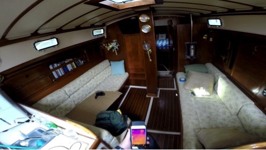
Given the complexity and broad scope of Marine Surveys, I now opine that the best infrared thermal imager for Marine Surveying is simply “the one you have with you”. Flippant as that may sound, having the second generation FLIR ONE thermal imager attached to my IPhone 6S+ phone when I examine and/or crawl through confined spaces is certainly a lot more convenient than setting up my FLIR P65HS imager.
Convenience Factor
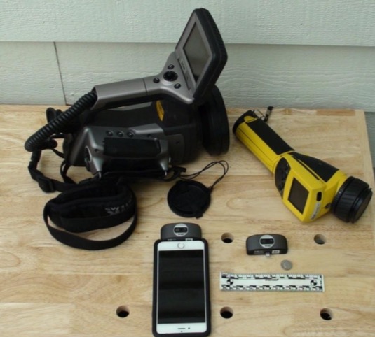
FLIR ONE attached to IPhone 6S+
Yellow FLIR ThermaCAM E4
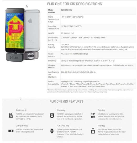
FLIR ONE second generation for IOS attaches to Apple products with a lightning connector:
Second Generation FLIR One IOS
Saving Images
The 2nd generation FLIR ONE for IOS uses the FLIR ONE IOS application (FLIR ONE app) to capture images. The 2.0.51 version of this application will capture infrared thermograms as a:
- Video (no visual … only non-radiometric movie ((.mov)) file)
- Photo (visual image and radiometric thermogram)
- Panorama (stitches visual image and radiometric thermogram)
- Time lapse (no visual … only non-radiometric movie ((.mov)) file)
When Photo and Panorama modes of image capture are selected, both visual and radiometric thermal images with the same Field of View are saved for use with Multi- Spectral Dynamic Imaging (MSX).
Since I use the FLIR ONE app on my IPhone 6S+ that has a storage capacity of sixty- four (64) gigabytes and cellular as well as WIFI connectivity, the images saved to my IPhone can be distributed as an:
- Email attachment
- Text message attachment
- Saved to external Internet enabled storage (Dropbox, Cloud)
- Posted to social media
or directly imported into the IOS FLIR TOOLS application on my IPhone for post- processing.
Post Processing
Radiometric images captured using the Photo and Panorama features of the FLIR ONE IOS app can be:
- imported to the IOS FLIR TOOLS application on my IPhone
- imported into the FLIR TOOLS+ program on my windows-based desktop computer or laptop
- imported into ThermaCAM Researcher Pro on my windows-based desktop computer
My selection for post processing methods is based on the various post-processing features inherent in each application/program.
Reporting
Since most of my Marine Survey reports are of a general nature augmented with visual and thermal images where appropriate, they are typically written using a word processor such as Microsoft Word with static images incorporated. However, both IOS FLIR TOOLS and WINDOWS FLIR TOOLS+ have the ability to place visual and thermal images in Adobe Acrobat templates to create reports as a PDF extension.
The WINDOWS FLIR TOOLS+ has an add-in for Microsoft Word that interfaces with FLIR TOOLS to create a Microsoft Word report.
| Feature | Flir Tools | Flir Tools+ |
| Import and group images using USB | x | x |
| Create IR/photo images groups manually | x | x |
| Measure temperatures using spots, areas, lines, and isothems | x | x |
| Measure a temperature difference (DeltaT) | x | x |
| Adjust object parameters | x | x |
| View a live image | x | x |
| Save IR JPEGs from a live image | x | x |
| Record a video sequence (SEQ) | x | |
| Replay and edit recorded sequence | x | x |
| Export a recoded sequence to AVI | x | x |
| Create a temporal plot | x | x |
| Export plot data to Excel | x | x |
| Export an image to CSV format | x | x |
| Create a Panorama image | x | |
| Create a PDF report | x | x |
| Create a Microsoft Word report | x | |
| Create text annotation templates for the camera | x | x |
| Add/edit text annotations and image descriptions | x | x |
| Listen to IR voice comments | x | x |
Summary
The best thermal imager for Marine Surveying is truly “the one you have with you”. While the FLIR ONE second generation for IOS will not take the place of my imager that has:
- Adjustable focus
- Supports additional lenses that change the Field of View (FOV)
- Displays and/or captures images at a frame rate higher than 9Hz
- Saves radiometric images in burst mode
But, when conducting a Marine Survey whose scope is more than Infrared Thermal Imaging, it is more often than not …. the imager that I always have with me.
References
Various screen shots from FLIR websites describing their products.
Standard for Infrared Inspection of Recreational Yachts & Small Craft Constructed of Fiberglass Reinforced Plastic and Composite Materials. 2011 Edition. Infraspection Institute.

