Efficient Plant
535 Plainfield Road, Suite A
Willowbrook, IL 60527
Ph: 630.325.2497
www.efficientplantmag.com
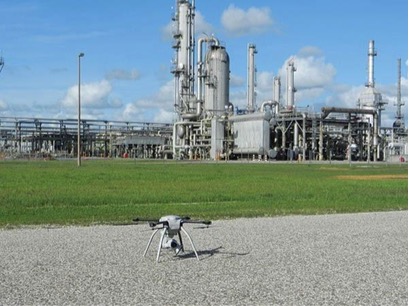 In industrial settings, drone- based technology is being used with increasing frequency to improve safety and inspect and analyze inaccessible areas. As the technology is developed, inspection is likely to be just a portion of what these flying devices can do.
Unmanned-aircraft systems are excellent and safe inspectors, but the future is in analyzing the data they collect.
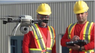
They can be as small as a pizza or as large as a picnic table. With the help of a licensed pilot, they can fly over and around heavy equipment. They can hover high above facilities and gather data from areas that would require scaffolding and cranes for humans to reach. They can maneuver into tight, hard-to-reach spots, such as industrial piping. Most important, they safely collect valuable data in record time and with minimal risk of unnecessary shutdowns or need for excessive manpower.
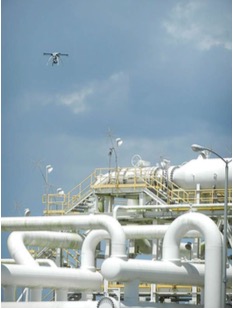 Unmanned aircraft systems (UAS)—more commonly known as drones—are being used effectively for a variety of reasons and in multiple industries. For now, the drones require a licensed pilot to manually maneuver them, just as if he/she were flying an airplane. This could change soon, according to Michael Cohen, CEO of Industrial Skyworks, Houston.
“What we want the drone to be able to do is to map its own environment and understand where there is a hallway or a wall, and where all the obstacles are in the facility,” Cohen said. “Then we want them to also send out laser signals and use onboard processing to create a 3D map and then understand and remember the environment. You have to get really geeky about this sometimes to see all the possibilities.”
This is the future of drone technology, Cohen said, and one day soon it could be advanced enough to not require a human to operate it. “This is the age of the robot,” he said. “Drone technology is already replacing human work. In a lot of cases, it could replace human work altogether.”
Drone technology is being used worldwide in manufacturing. At Reliance Industries Limited (RIL-Hazira), a petrochemical plant in Gujarat, India, there was some damage to a large boiler. Operators were having trouble inspecting the boiler from the ground floor. The boiler operates at more than 1,200 F, making it an unsafe scenario to send a mechanic to the top to inspect it.
“We could not determine whether to shut down the plant, so we wanted to change our tactics and see what else could be done,” said RIL-Hazira’s head of engineering, NKK Prasanna. “We got a license for the drone to inspect the equipment at a height of 72 meters (236 ft.)”
There were regulations RIL-Hazira needed to deal with first. For example, they had to inform a nearby police station to monitor the strict rules regarding UAS use for the petrochemical industry. “We launched up to 32 meters (105 ft.), covering around 15 to 20 meters (49 to 65 ft.) radius,” Prasanna explained. “We took a lot of still photographs and video to determine the precise problem with the boiler. We got the data we needed to plan the shutdown with some organizations and structure and were able to fix it before we had a breakdown. This was our first experience with drones.”
Since that first successful experiment more than five years ago, RIL-Hazira has continued to use drone technology. The company hired an analyst from the Indian Institute of Technology to work with the drone-collected data.
“One of the main focus areas for the plant were the instrument cables and electrical wiring that runs through the pipes throughout the plant,” Prasanna said. “It is difficult for us to go to the 15-meter level for inspection. So we combined some standards and gave them to the drone expert. He put all the standards in the drone and we launched it through 1.52 kilometers (1 mi.) of pipeline. It detected the exact location of the defect. It gave us the latitude and the longitude of the particular problem and detected where someone left a heavy object inside the pipe when they were working on the electrical cables. We were able to fix all of this because the drone was able to find it.”
The RIL-Hazira company doesn’t own drones. Instead, it rents them when required. Prasanna said this technology has greatly helped to improve plant reliability—not only for the boilers, but also for the entire instrumentation system. “When you have data and you can compare the photographs and detect the GPS location, many man hours of inspection have been avoided by using the drone,” he said.
The next drone project for the company is to use the technology at a higher elevation. “It takes a lot of time and money, so we are developing a way to attach software to the drone,” Prasanna said. “It goes along the pipeline and gains a lot of waypoints. Once it comes back, you can take all the data and determine the condition of the pipeline. The next project is conceptualizing storage-tank inspection. The drone camera will take photographs and allow us to determine the condition of the tanks.”
When human inspection tests the limits of safety, unmanned aircraft systems can be the answer.
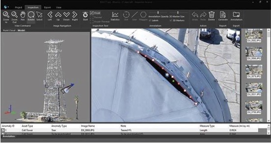
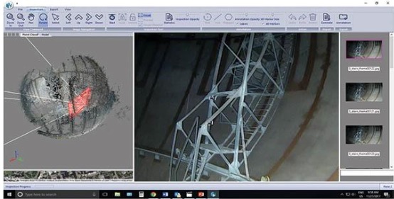
This screenshot shows the images and analyses of a cell- tower inspection using Industrial Skyworks’ Blue View system.
Analyzing the Data
Collecting the data is the first step. Analyzing it is the critical step. This is where companies such as Industrial Skyworks come into the equation. The company primarily performs building inspections (roofs and walls) for architects. They also work extensively with inspection companies in the oil-and-gas industry.
“When inspecting a building, the company provides a video,” Cohen explained. “For the majority of cases, they supply photographs, which we call raw data. One building could have 5,000 photographs. We take all the raw data and convert it into something usable. In many cases, that could be two-dimensional maps or three-dimensional imagery. We run the analytics on it.”
For example, the company may use 5,000 photographs from a building to create a 3D model. The model makes it possible to analyze factors such as the heat signature of a building to determine where it is leaking energy. The data is then reported to an engineering firm.
“There are two pieces in which we get involved,” Cohen said. “One would be a full solution with everything from providing pilots in the field, acquiring data with drones, processing, then making a presentation with software that we call Blue View. Then we do the analytics and reporting. A partial service could be an engineering firm that has their own drone pilot and is acquiring a whole bunch of data. We take their data and process it and perform the analytics.”
Application Examples
Cohen spent 18 years as a commercial pilot. In 2011-12 he was a consultant for aviation companies such as Jet Blue and American Airlines. “This is where I discovered drone technology,” he said. “At first it was entrepreneurial. I just knew it was going be huge and I wanted to be involved. At that point, I started film and television work and very quickly decided that portion of the work was interesting, but we didn’t want to be on that side of the market. We wanted to be in industrial inspections.”
The majority of the market depends on the sensor (which is a camera), Cohen said. This is where most of the impact is in building inspection. “Think about being able to look at a building and see that the bricks are falling off,” he explained. “Maybe it’s in an industrial setting where things are broken. They are corroding or wearing down. Visual inspections can determine this. Then you can layer on things like a thermographic camera to look at heat signatures. A building that’s losing energy is a problem that we can help with. There are some multi-spectral cameras. One example of this is looking at crop health. You can get a color map and then understand what plants are doing really well and which ones are under pressure.”
Latest Innovations
Indoor drones are the latest technology, according to Cohen. These drones are capable of flying free of GPS signals and/or do not rely on the earth’s magnetic compass. They are able to fly in just about any building, including steel structures. “This opens up the technology to anything in the defined-space world. Now, rather than sending people in to inspect these things, you can send flying robots to go in and pick up all this data. This is really, really exciting for us,” Cohen stated.
Industrial Skyworks’ Blue View software uniquely creates a three-dimensional model from drone data, then connects the model with raw photography. “To be able to click on a 3D model and draw a raw photograph of the asset is really powerful,” Cohen explained. “We want to deal with raw photographs all the time. We don’t want anything altered or stitched together. If you are looking at something like a crack in a weld, and you are going to stick photographs together, that can obscure the problem. So the mission fails. We just want to deal with very high-resolution, raw photographs. Things we are able to do include collecting qualifiers like the amount of corrosion on something like the inside of an oil tank. Perhaps it’s down for maintenance and needs to be inspected. We have an indoor drone now that is able to replace scaffolding. We get all this visual imagery so now we can perform analytics.”
Anything that is remote and difficult to look at, particularly with regard to inspection and maintenance work, can be analyzed with this technology, Cohen said.
“For instance, let’s say you have an overhead crane in your shop which requires maintenance twice a year,” he explained. “You must build scaffolding and climb up to look at the mechanism. But now you can send up a drone to take a look. This can be done in real time with a pilot standing next to the inspector. Or you can capture all that imagery, digitize it, put it into software like Blue View, and then look at it when you need to.”
New developments include looking inside a conduit, pipeline, or boiler. “We are seeing a huge amount of penetration for the drones that are able to fly inside these types of structures.”
The Future of Drone Technology
The smallest industrial drones have a diameter similar to that of a large pizza, weigh about 5 lb., and are made of plastic or carbon fiber. The next size is about the diameter of a hula hoop. Some applications have heavy-lift capabilities and can be as large as a picnic table. These large drones are primarily used for film and television with a camera that can weigh as much as 25 lb.
The future of this technology resides in its autonomy, Cohen said. “The ability to be able to set something like a thermostat and have it three-dimensionally fly through an environment, like a refinery, picking up all this data once a day, is remarkable,” he said. “It’s like science fiction. Think about the possibilities if you can look at the things that are really valuable to running the environment, and do that perfectly and autonomously.
“In the very near future, rather than just pulling all this data, we will be able to onboard process it and be able to discover the problems. If an industrial pump is running at 100 F, when it runs really hot it may mean there is no oil in it. It will go to 300 deg. and glow red, and then it’s going to fail. We can look at the heat signature of the pump with a thermographic camera using an autonomous drone. If we understand the good range and the caution range of temperatures, at an autonomous level the drone will be able to see when a pump is running in a cautionary level and it will send an alert to an operator letting him know this particular pump is about to run to failure. That technology is on our doorstep. I think we are less than three years away from this.”
The possibilities are limitless, Cohen believes. “The piece I was just describing really resides within the blanket of artificial intelligence, which boils down to computer vision,” he said. “To be able to understand the patterns of things that are problems is valuable. Think about building the recognition of something that’s wrong and then building a feedback loop of machine learning. The more bad pumps we find and understand what they look like, the better and smarter we get at identifying those sorts of things.”
“You have a collision of these two worlds,” he continued. “The drones that are now able to fly in and read complex environments, using things like sonar and lasers to understand where the walls are, they are thinking in real time about how to avoid obstacles and duck under pipes and go through very thin channel ways in real time. They are learning how to identify problems. It’s Terminator-type stuff. It’s very sci-fi.” EP
Federal Aviation Administration Regulations for Industrial Applications
a remote- pilot- airman certificate with a small- UAS rating or be
supervised by a properly rated person.
- A person operating a small UAS must either hold a remote-pilot airman certificate with a small UAS rating or be under the direct supervision of a person who does hold a remote-pilot certificate (remote-pilot in command).
- Unmanned aircraft must weigh less than 55 lb.
- Visual line-of-sight (VLOS) only; the unmanned aircraft must remain within VLOS of the remote pilot in command and the person manipulating the flight controls of the small UAS. Alternatively, the unmanned aircraft must remain within VLOS of the visual observer.
- At all times the small unmanned aircraft must remain close enough to the remote pilot in command and the person manipulating the flight controls of the small UAS for those people to be capable of seeing the aircraft with vision unaided by any device other than corrective lenses.
- Daylight-only operations, or civil twilight (30 min. before official sunrise to 30 min. after official sunset, local time) with appropriate anti-collision lighting.
- First-person view camera cannot satisfy “see-and-avoid” requirement, but can be used as long as requirement is satisfied in other ways.
- The UAS maximum groundspeed is 100 mph (87 knots).
- Maximum altitude can be no more than 400 ft. above ground level (AGL) or, if higher than 400 ft. AGL, remain within 400 ft. of a structure.
- Minimum weather visibility of 3 mi. from control station.
- No operations from a moving vehicle unless the operation is over a sparsely populated area.
Michelle Segrest is President of Navigate Content Inc., and has been a professional journalist for nearly three decades. She specializes in creating content for the processing industries. If you have an interesting efficiency, maintenance, and/or reliability story to tell, please contact her at

