Gregory R. Stockton
Stockton Infrared Thermographic Services, Inc.
8472 Adams Farm RoadRandleman, NC 27317Ph: 800-248-SCAN
Ph: 336-498-GREGwww.StocktonInfrared.com
Aerial infrared (IR) thermal imagery from surveys of large facilities, industrial complexes, campuses, military bases, and cities can be used for many purposes. Steam and condensate return lines, hot water lines, chilled water lines, supply water mains, distribution piping, storm water drains, sewer lines, electrical switchgear, and buildings can all be monitored by looking at surface temperatures and thermal patterns. Having one giant thermal and visual image of a campus can help facility managers improve their preventive maintenance programs and to comply with various energy and regulatory requirements. This paper shows examples of how thermal and visual data are collected, processed, and delivered, and the many ways they are used to benefit an owner.
Generally speaking, the farther away one can get from the object of an infrared survey, while maintaining the needed spatial resolution and thermal sensitivity, the more usable the data become. Wide areas and large objects are most effectively imaged from the air. The use of high-resolution aerial infrared imagery is often the only way that one can see the slight nuances of temperature differences and the trace patterns of heat that are needed to make judgments about the condition of objects on the ground. In order to produce an easy to understand, high quality and useable report, the data must be collected and processed in an efficient and effective way.
Aerial infrared applications can be divided into two categories; those where a straight-down view and/or a large area view is needed, and those where long distances must be covered in a limited amount of time. The methodology for taking aerial infrared thermograms is similar in many ways to taking aerial visible photographs. To collect the data, the aircraft flies over a given area with a camera mounted to the airframe and oriented looking straight-down (NADIR) to the ground. The imagery is then stored on a computer hard drive and later post-processed. Where aerial infrared thermography differs from aerial visible photography is the time of day when the survey occurs and the wavelength of the imagery that the detector collects. IR thermography of ground objects is performed at night. Thermography reveals sources of heat and the relative differences in heat from one object to another.
Infrared imagery is a grayscale picture whose scales, or shades of gray, represent the differences in temperature and emissivity of objects in the image. Objects in the image that are lighter in color are warmer and darker objects are cooler. No object in an IR image is detected via visible light wavelengths (400-700 nanometers); rather, only from thermal infrared wavelengths in the 3000-5000 nanometers or 8000-14000 nanometers range. Lights and other relatively hot objects are very evident, but as a result of their heat emissions, not their light emissions. An example of this is a street light that can be seen in the IR imagery, but only because the ballast and bulb are warm. Infrared imagery is usually recorded onto digital media and later copied to DVD-video, videotape and/or captured as digital image files. The images may then be modified in a number of ways to enhance their value to the end-user, such as creating false-color images, adjusting the brightness and contrast of the image to highlight a particular anomaly or zooming in on different areas of interest. These data can be post-processed and used to prepare predictive maintenance (PdM) reports on the various systems.
Proper selection of the aircraft, aircrew, navigational aids, imaging systems, data acquisition, and image processing systems are all-important to successful aerial infrared surveying. In order to get professional results, equipment that is specifically designed for the task must be utilized. Because it is a relatively expensive operation, the job must be done correctly and safely the first time.
Both helicopters and light airplanes can be used to perform aerial infrared surveys. Helicopters are best used if the number of targets or distance between targets is low because there are inherent problems with vibrations, slow ferry speeds and high operating costs associated with their use. Airplanes are used in wide-area thermal mapping. The IR imager must have higher spatial resolution because it must operate at higher altitudes and therefore farther away from the target. The imager must be fixed mounted solid, fixed manually articulated or turret-mounted. In any case, a well-maintained aircraft, experienced aircrew and an imager capable of the resolution required for the intended task must be utilized. The type of infrared imager used will dictate how images are recorded and saved. Controls must be within easy reach and all equipment in the aircraft must be secured, with wires labeled, shielded from electromagnetic interference, and out of the way. Precise navigation is important in any aircraft and particularly so in nighttime aerial infrared operations. Most aerial infrared imaging is performed at night because reflected and direct daylight solar radiation usually adversely affects the imagery and can damage the imager.
Flying low and slow and maneuvering in the dark makes nighttime aerial infrared imaging a job for professional pilots that have been specifically trained and who are experienced in this particular type of work.
Using a non fixed-mounted thermal imager to survey a couple of buildings or a few acres of ground can be done by flying over, locating the target(s) in the imagery, saving the data and putting it together into a report. This works for small areas where thermal mapping is not necessary, but it is impossible to make precise thermal maps of a whole complex, campus, military base or city without compositing a multitude of images. During the flight, the aircraft flies straight, smooth lines on a pre-planned grid, allowing overlap and sidelap of the imagery. The IR operator manages the sensor data-acquisition following a structured checklist for orderly data file management.
|
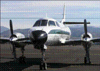
Figure 1.
Aerial IR imaging/data collection system and aircraft |
 |
In order to produce ortho-rectified thermal maps, much more information must be gathered and tagged to the IR imagery. The imagery must be collected with a precise direct-digital timing system, a 3-axis ring-laser-gyro and an inertial navigation system (INS), which is tightly-coupled to a real-time differential GPS satellite positioning system that provides x, y, z positioning of the sensor at all times (see Figure 1). After data are collected, the digital infrared imagery is processed into a series of ortho-rectified image tiles, which are then stitched together to create a mosaic thermal image (see Figure 2). A computer system puts all this information together using a digital elevation model (DEM) of the scene that consists of a uniform grid of point elevation values and the position and orientation of the camera with respect to a three-dimensional coordinate system output. The result is presented as a high-resolution thermal image in the form of a geo-TIFF, which is compatible with any GIS software. Once high quality digital thermal and photographic ortho-rectified maps are created, they can be added as layers to other data sets, to existing or new CAD drawings and GIS maps. Digital data can also be post-processed in other ways, such as creating false color imagery to highlight areas of interest, adding temperature data and/or creating graphic reports.
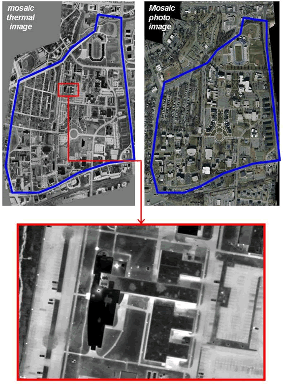
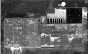
Figure 2. Mosaic visual and infrared image of a small university
When an object on the ground (or in the ground) is producing heat, the surface temperatures may be affected. When an object is heated or cooled, differences in the mass of the object can be observed thermally. So, during the day, the sun heats objects directly by radiation and indirectly by raising the ambient temperature. Then, at night, these objects cool at different rates according to their mass and other properties. Judgments can be made about these objects based on their thermal characteristics. There are many applications for aerial IR imagery and examples are shown below.
Aerial infrared can help managers monitor their steam distribution system. Thermal contrast between active lines and the surrounding ground is usually good depending on the depth of the line, temperature, flow and the materials covering the lines. The entire system can be flown, a mosaic thermal image produced, and the areas with suspected problems can be pinpointed and documented.
Steam and condensate return lines are almost always readily visible with aerial infrared imaging, even when no notable problems exist. This is due to the fact that no matter how good the insulation, there is usually some heat loss from the lines which makes its way to the ground surface. Problem areas are generally quite evident, having brighter infrared signatures that exceed the norm. Steam line faults normally appear as an overheated line or as a large hotspot in the form of a bulge or balloon along the line (see Figure 3). If a steam line is buried directly in the ground with an insulating jacket, a leak will usually saturate the insulation, rendering it largely ineffective and it will begin to transfer heat into the ground around the leak.
Overheated lines often occur when the steam line is located in a conduit or tunnel. If there is a leak in the line, it will heat up the conduit with escaping steam. Some leaks show up as an overheated manhole or vault cover. Manholes or vaults that contain steam system control apparatus which are leaking, will often heat the covers to warmer than normal temperatures. Unless these leaks are severe enough to significantly raise the manhole temperature above the normally slightly elevated temperatures, these leaks can be difficult to identify. In fact, steam line infrared imagery can be a little misleading, unless one understands and interprets the relative brightness and temperature of a given line correctly. For instance, a steam line that is the same temperature from one end to the other that passes under different surfaces and materials can exhibit a variety of real and perceived temperature variations. Five different apparent temperatures will result from the same temperature line that runs under a grass-covered field, an asphalt roadway, a concrete loading dock, a gravel-covered parking lot and a bare earth pathway.
The longer that a steam leak, excessive heat loss on a line, and/or undetected draining of fluids (see Figure 4) goes undetected, the greater the energy loss, the more make-up chemicals have to be added, and the more potential exists for negative environmental impact and waste. District heating systems can be flown rapidly and inexpensively to provide thermal data for asset management planning and predictive maintenance. As a result of finding and repairing leaks in the steam system, energy usage can be reduced with all the related benefits.
The imagery approach described above is qualitative. It identifies and locates problems in steam systems based on their anomalous heat signatures. However, this method does not quantify the amount of heat loss. In order to develop quantitative information, some additional work is needed in the form of additional field work in the infrared data acquisition phase and heat transfer analysis in the post-processing phase. Return on investment for obtaining and processing quantitative data is much, much lower than finding the leaks and repairing them, since there are often so many leaks, that by the time they are repaired, it is time for another IR survey anyway.
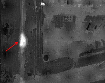
Figure 3. Typical steam leak in a distribution system
In order to know exactly what the radiated energy of any object is, the characteristics of the sensor, atmosphere and the target must be taken into consideration. One must also know the transmission, emissivity and reflectivity of the target. There are big differences in the emissive qualities of objects on the ground, such as concrete, asphalt, grass, dirt, etc. The ability to obtain quantitative measurements is built into radiometric imaging systems, but one must use a radiometric infrared imaging system to collect the imagery and collect it in a form that can be post-processed.
Heat energy moves by conduction, convection and radiation. In order to make meaningful quantitative thermal calculations, the pipe’s or pipe’s content’s temperature, insulation properties and the complete thermal properties of all the materials in the ground (specifically heat capacity, thermal conductivity, and density) must all be known and made part of the calculation. As-built drawings and the thermal properties are not always readily available, if available at all. This generally means that estimates of the heat loss, implications of temperature values obtained and quantitative evaluation of the pipe’s performance can be developed only as estimates.
Even though some large format thermal imaging systems are fully capable of rapid frame-by-frame digital temperature data acquisition of every pixel of every IR image, the cost of quantitatively gathering measurements and using steady-state and transient heat transfer analysis calculations (finite element analysis), make quantitative measurement a much more expensive step than simply using the image data to make judgments based on the experience of the person analyzing the thermal data. Most of the time, identifying leaks and excessive line heat loss is straightforward, but making calculations regarding insulation effectiveness and other qualities is an additional step that adds cost, which may add value, but also could offer a much lower return on investment. In other words, identify leaks and large heat loss issues before trying to quantify heat loss.
High temperature hot water (HTHW), medium temperature hot water (MTHW) and low temperature hot water (LTHW) lines benefit similarly to steam distribution and condensate return systems, with an associated degree of difficulty in surveying because of the declining temperature difference to that of the surface. Chilled water supply (CHWS) and chilled water return (CHWR) lines are usually cooler than the surface temperature and can be surveyed for thermal loss and leaks as well (see Figure 5).
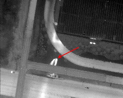
Figure 4. Steam line leaking up, onto the ground surface
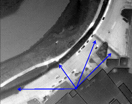
Figure 5. Buried chilled water line cools the surface above the line
Detecting electrical faults on high voltage electrical transmission lines is fairly easy and can be accomplished rapidly from a light aircraft or helicopter. Typical problems are loose and/or deteriorated connections. Qualitative data are easily collected, but, a small target (for example a transmission line splice) from a moving, vibrating aircraft cannot be measured from safe flying distances, although it can be detected. These spot sizes are unmanageable and inaccurate on any target that does not have a large homogeneous heat signature. However, these anomalies can be seen (see Figure 6), and by comparing them to similarly loaded phases or equipment, potential problem areas can be identified, saved, and marked on a map. For more accurate measurements, if desired, a ground verification team can be used to inspect suspect hot spots from the ground (cloudy nights are best) and quantify the findings of the aerial IR survey, if needed. They will be closer to the target and with a powerful lens on a stable surface – much more accurate. Because they are smaller, lower to the ground and often are run through populated areas with much thermal clutter, high voltage electrical distribution lines are much more difficult to survey from the air and are best left to ground-based infrared thermographers.
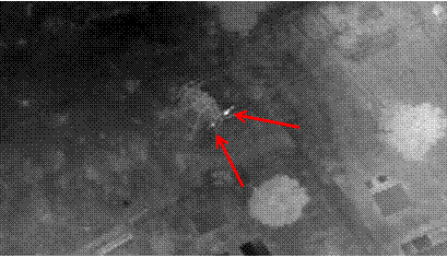
Figure 6. Hot connections on a high voltage transmission line
Storm water collection systems are engineered to discharge into surface waters to efficiently drain rain water from a given area. But all too often, these systems convey pollutants from illicit connections, degraded sanitary sewers and other sources. Locating these point sources on the ground is a labor-intensive task, often relying on sampling data from sites that may be blocks or even miles from the actual source. Liquids flowing into the body of waterways can be identified using aerial infrared thermography, as long as there is a temperature difference between the two. Typically, dry weather flows are heated by having been underground at some point and can be detected by using aerial infrared thermography when it joins the water in a creek (see Figure 7), stream, river, lake, or ocean during cooler times of the year. Leaks from nearby water, sewer and/or storm water lines and direct run-off from a sloped surface can be detected because they produce a warm flow over the ground toward the water and a warm plume joining and flowing downstream with the main body of water.
Waterways are best surveyed during times of the year when the ambient temperature at night is well below (a ?T of 15C degrees) that of the ground temperature (1 meter deep) and when overhanging foliage is minimized. Aerial infrared surveys can help managers identify, quantify, document, and remove previously unidentified and sometimes illicit discharges. Aerial infrared surveying can also be used to track pollution such as waste spills or oil spills and monitor sewage treatment plant discharges, manage heated water from power plants (see Figure 8), monitor ground water seepage into rivers, streams and lakes, and measure the amount of fresh water from ground sources that are introduced into an estuary.
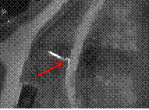
Figure 7. IR image of a storm water drainage system outfall flowing into a creek
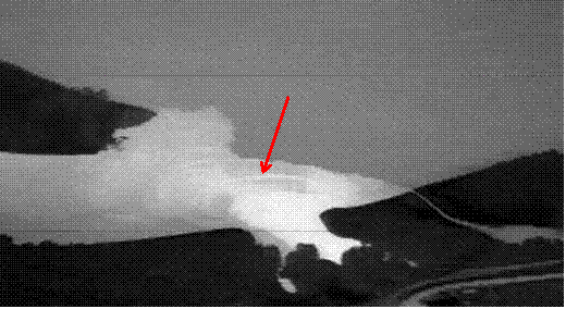
Figure 8. IR image of cooling tower discharge into a lake
When a road or building complex is planned, the site can be flown over with aerial IR to determine if any geothermal activity is present at the surface. This will allow the planner to route the road around the activity or decide the site is unsuitable for the intended purpose.
Aerial infrared can be helpful to the firefighters of structural fires. Often, the smoke escapes the building from a different location than the hottest part of the fire. These areas can be imaged and the firefighters informed as to the location of the hot spots.
Aerial infrared imaging can be used to monitor and manage forest fires. By creating accurate mosaic thermal maps (see Figure 9), fire management and suppression efforts can be adjusted for active fires. This information can be sent immediately to those in charge of controlling fire lines. Thermal intensity is resolved to classify the hottest sections of the active fire, therefore pinpointing the areas of most intense thermal energy. These digital aerial maps are loaded to hand-held GPS devices to enable ground teams to most rapidly navigate directly to the hotspots by either walking, driving, or flying in a helicopter. Thermal IR provides an important visual reference locator by identifying the hot spots with respect to terrain features in the thermal imagery. Positive identification of hotspots is accurate and rapid, even through dense smoke.
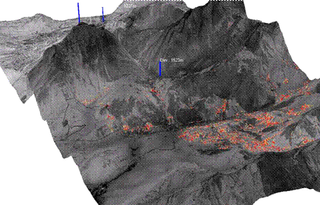
Figure 9. 1000-IR image fire mosaic draped on 3D terrain model, created in one hour
Landfill fires (see Figure 10) can be hazardous to the surrounding environment. Knowing where, how many, and the extent of these fires underground is useful information to those in charge of containing or extinguishing them. Similarly, peat, coal and wood chip piles, which combust spontaneously, can be monitored.
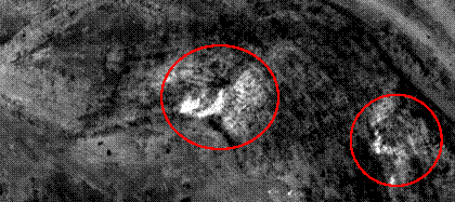
Figure 10. IR image of a portion of a landfill. Red circles indicate subsurface fires
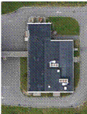
There is no better example of using aerial infrared thermography on buildings than that of flat and low-sloped roof moisture surveying. There are two types of surveys generally available; surgical roof moisture surveying and wide-area roof moisture surveying.
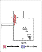
Roofs are an expensive and onerous asset to maintain. Entrained moisture in the insulation and other roof substrates is indicative of leaks in the waterproofing, and seam and flashing failures. Precise marking of the entrained moisture in a roof on a CAD drawing provides a significant benefit to the building asset manager (see Figure 11).
Regular aerial infrared surveys help the owner assess the condition of a given roof based on unbiased hard data, by quantifying areas of moisture contamination. NADIR aerial imagery is a very effective method because infrared images are taken ‘plan view’ and large areas can be seen in one image allowing the slightest temperature differences to be noted.
High-resolution aerial imagery captures large areas at once, while lessening reflection problems and eliminating image perspective problems. Aerial thermographers can survey many roofs in one night while conditions are good, and analyze the data carefully and methodically in an office setting. Plan view imaging allows for the precise and accurate marking of areas of suspect roof moisture contamination. Infrared images, visual images, and CAD drawings (see Figures 12 & 13) can be reconciled closely, making the report accurate, clear, concise and easy to understand.
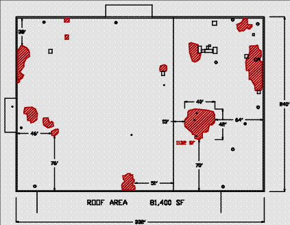
Figure 11. CAD drawing with areas of subsurface moisture defined and quantified
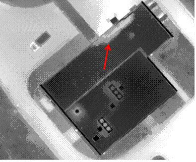 |
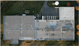
Figure 12. 10cm thermal image of a small flat roof with arrow indicating subsurface wet area. In the lower portion, a thermogram, photo, and CAD drawing are shown |
|
THERMOGRAPH
|
PHOTOGRAPH
|
CAD DRAWING
|
 |
 |
|
 |
|
Figure 13. Mosaic visual and thermal image |
These aerial roof moisture surveys are carried out for roofers, roof consultants and insurance companies. Large areas of cities, like industrial parks and high concentrations of buildings with flat roofs are thermally surveyed from generally higher altitudes, obtaining lower resolution imagery. This lower resolution imagery acquisition decreases data collection time and data post-processing time, which in turn reduces the per acre cost.
A spreadsheet can be provided to the insurance company with the address and roof moisture “rating” so that attention can be paid to any insured building showing a high rating, indicating a higher probability of roof damage. This data, combined with an on-site visit can help the insurance company’s underwriting department assign accurate premiums and deductibles. On the claims side, in the event of roof failure or a catastrophe such as a hurricane or tornado, liability will be limited to pre-failure conditions.
Roofers and roof con-sultants can use the imagery and address information to analyze the business potential in a given area. They can also use the data for target marketing their roof services to high-potential customers with damaged roofs.
Wide areas are most effectively imaged from the air, as long as thermal sensitivity and spatial resolution needed for a given application are maintained. A thermal mosaic image of a large area of the ground can contain imagery that has multiple uses as described above.
Visit out Sponsors:
![]()
Electrophysics


Advertisement