
Defensible Aerial Thermal Evidence
Drew Thacker
DFW ASTM PROS
Holiday Drive
Colleyville, TX 76034
817-482-6258
Almost every week, I get an email asking me to review someone’s aerial thermal inspection. Commercial roof. Storage tank. Photovoltaic array. Building envelope. Sometimes a flare stack or a substation bushing. The assets change. The question doesn’t.
“What do you think?” My answer is always the same, too - “I don’t know.”
That surprises people. They’ve sent me fifty thermal images, an orthomosaic, maybe some visible photos. Surely that’s enough to spot trapped moisture, deteriorated insulation, or a coating defect. Usually, it isn’t. So instead of answering, I start asking.
What were you inspecting? What was the objective? When did you fly? What were the conditions? Had it rained? Did you walk the asset first? What did the visible images show? Did you verify the anomaly? And the one that matters most - why do you believe this image shows what you say it shows? Notice something? Not one of those questions asks about the drone. Not one asks about the camera brand or the processing software. Those don’t determine whether an inspection is defensible.
Here’s what I’ve learned after enough of these requests: aerial thermography has surprisingly little to do with drones. It has everything to do with understanding the conditions under which a measurement was made.
A thermal image records what the camera sees. It cannot explain why that pattern exists. For that, you need context.
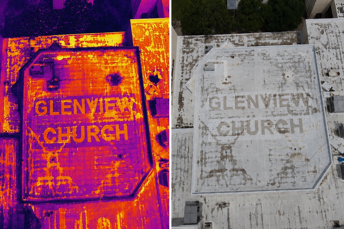
Figure 1.A thermal image records temperature patterns. The visible image reveals roof construction, coatings, repairs, drainage, and surface condition. Neither image explains the anomaly by itself. Context transforms measurements into evidence.
Reconnaissance Is the First Phase
Most people think an inspection starts when the drone lifts off. Mine usually starts days earlier. A client calls on Monday for a Wednesday flight - I’m on Google Earth before I hang up. Terrain. Buildings. Trees. Power lines. Launch spots. If I can, I drive by beforehand. I don’t fly; I just look.
Where’s the afternoon sun hitting the roof? What’s casting shade? Is there a nearby HVAC unit that might confuse the thermal signature? What’s the traffic pattern? Where are the overhead hazards? What am I actually dealing with?
I pay attention to what the satellite image doesn’t show, too. Sometimes a roof that looks pristine from above is covered in gravel or reflective coating that hides the substrate. Sometimes a building that appears straightforward from the street has a complex parapet or a dozen rooftop penetrations that will affect the scan. You can’t plan for those variables from a desk. You have to see them.
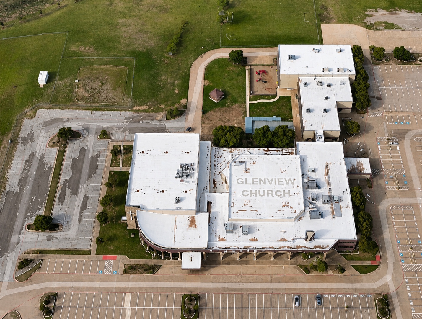
Figure 2. Reconnaissance begins before the aircraft leaves the ground. Satellite imagery provides critical context for building orientation, access, surrounding structures, shading, and environmental influences that affect thermal interpretation. Base imagery: Google Earth (Imagery © Landsat/Copernicus).
By the time inspection day arrives, I’ve already started. It took me years to realize what I was doing. I wasn’t preparing for the inspection. I was building context. Every observation added a piece - roof construction, building orientation, surroundings, recent weather, surface condition. None alone answered anything. Together, they started to explain the thermal pattern before I ever saw it.
When the Camera Lied
I remember one roof in particular. The thermal images showed a massive hot area - widespread, aggressive-looking, the kind of signature that makes clients reach for replacement budget spreadsheets. The client was already planning to replace the entire membrane.
When I walked the roof, I found something the satellite image hadn’t revealed, and the thermal camera couldn’t explain: one section had recently received a reflective coating that hadn’t fully cured. The application was uneven. Where the coating was thickest, the emissivity had changed. The thermal difference the camera was reading wasn’t moisture at all. It was a material property difference - a surface that was simply radiating differently than the substrate beside it.
The anomaly was real. The interpretation was wrong - ground-truthing saved that client six figures. It also reinforced something I already believed but hadn’t fully articulated: the camera is not the investigation. It is one instrument in the investigation. The conclusion doesn’t belong to the camera. It belongs to the thermographer who understands what the camera is actually measuring. That changed everything.
Reconnaissance isn’t something you do before the inspection. It is the first phase of the inspection.
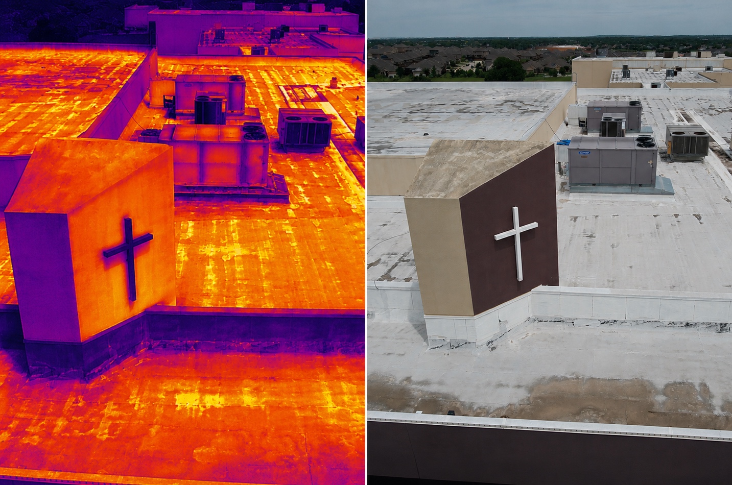
Figure 3.The same roof viewed in thermal infrared (left) and visible light (right). The thermal image records surface temperature patterns, while the visible image reveals construction details, coatings, drainage, and equipment. Neither image explains the observed anomaly by itself. Defensible conclusions emerge only when thermal measurements are interpreted within the context provided by the visible inspection and field observations.
Now when someone sends me a thermogram and asks, “What do you think?” I don’t study the hot spot first. I study everything around it.
The question is not “What am I seeing?” The question is “What does this pattern actually represent?” Without context, it’s simply a picture. With context, it becomes evidence.
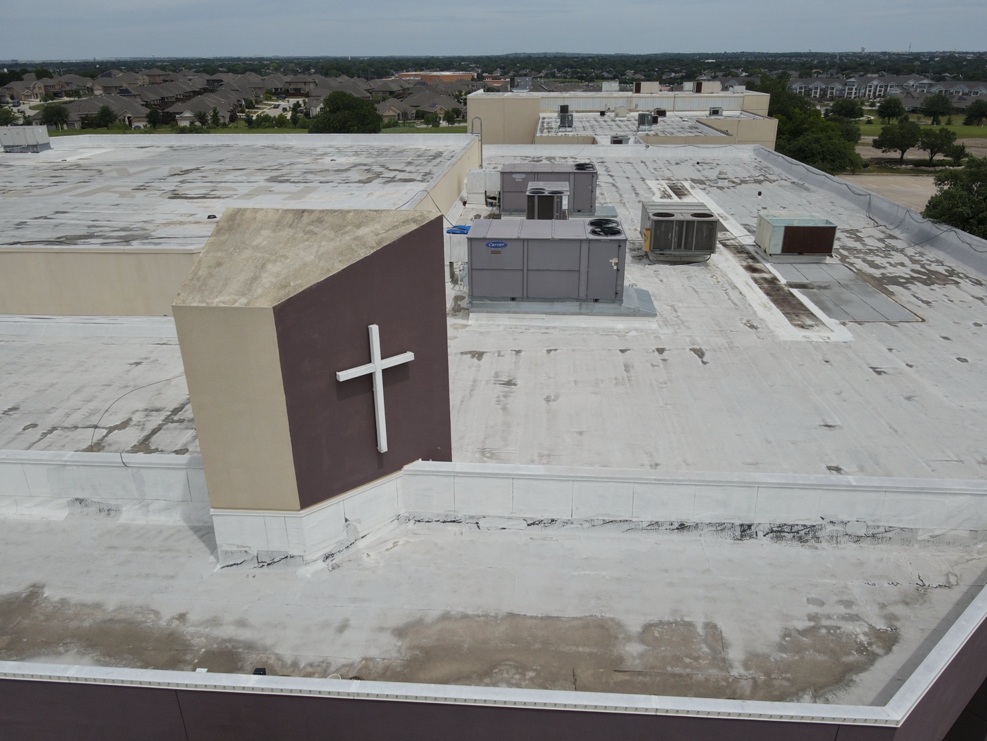
Figure 4. Cross/parapet church (visible, oblique). The headwall, elevation change, HVAC equipment, and drainage patterns are all readable from the air before landing. This is the reconnaissance walk from altitude - context building before measurement begins.
The drone didn’t make that inspection defensible. Neither did the camera. They just collected measurements. Whether those measurements become evidence depends on the questions you asked beforehand, the observations you made during, and the discipline you exercised after.
Technology is no substitute for judgment. Judgment transforms data into evidence.
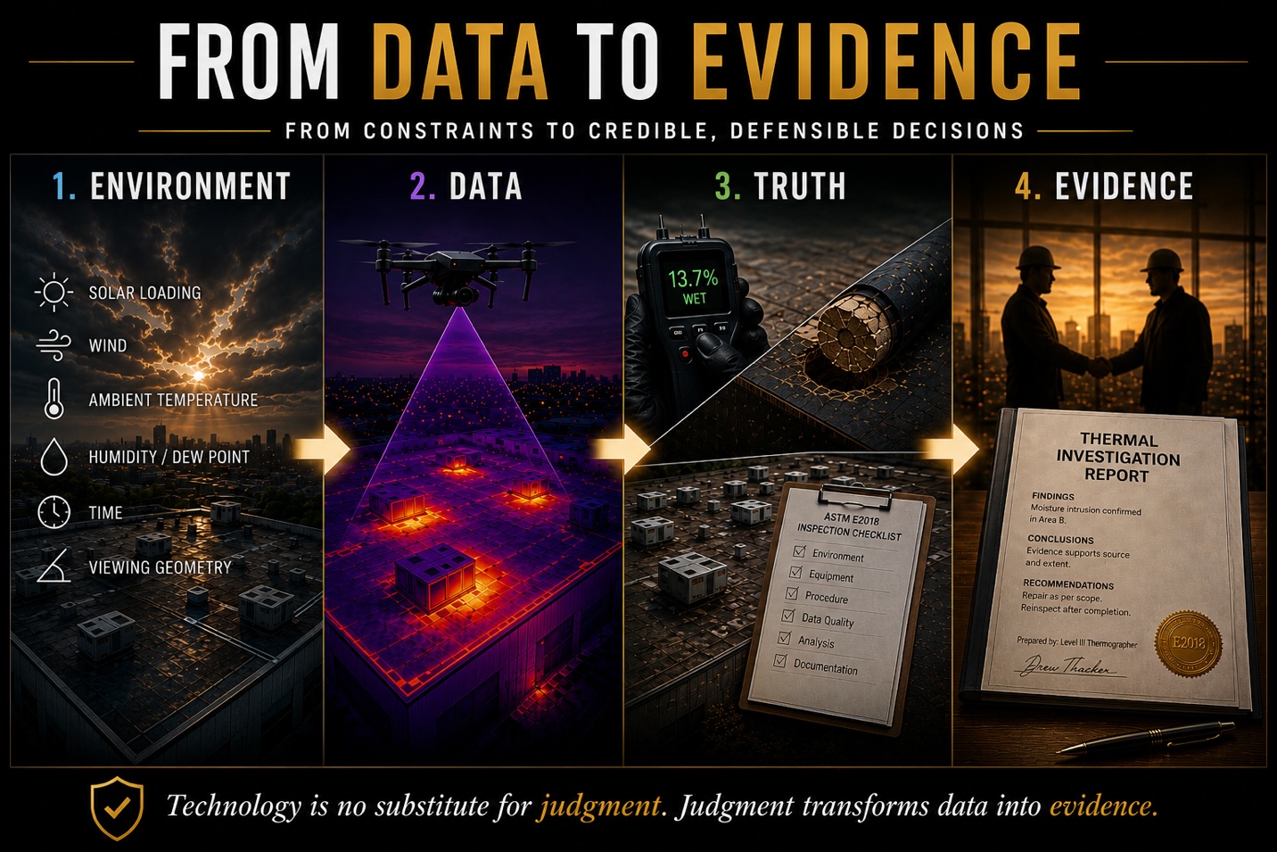
Figure 5From “Data to Defensible Evidence”. Defensible aerial thermography is not created by the drone or the thermal camera. It results from disciplined preparation, environmental awareness, accurate measurement, verification, technical interpretation, and complete documentation.
Earning the Conclusion
So maybe the better question isn’t, “What do you think about my thermogram?” Maybe it’s, “What have I done to earn confidence in this conclusion?” The answer lives in specifics. Did you document the conditions - surface temperature, ambient temperature, wind speed, time since last rain, solar loading? Did you walk the asset before you flew it? Did you verify the anomaly with a secondary instrument - a moisture meter, a core, a contact reading? Did you correlate the thermal signature with the visible image taken simultaneously? Can you explain, in plain language, why the pattern you observed is consistent with the conclusion you’re drawing?
If you can answer those questions with evidence, your conclusion is defensible. If you can’t, it’s an educated guess - and educated guesses don’t hold up in front of a building owner, a claims adjuster, or a courtroom.
Clients don’t remember your drone model or your software. They remember whether you were right. Long after the gear is packed away, the images archived, and the report delivered, what remains is credibility. And credibility is earned long before the first image is captured.
That’s where defensible aerial thermal evidence begins.
Drew Thacker is a Level III Thermographer, FAA Part 107 Remote Pilot, and ASTM E2018 Consultant specializing in aerial building envelope and roofing investigations.
Advertisement
